METAR & TAF Glossary
Every abbreviation that can appear in a METAR or TAF, grouped by category. For the basics and a fully worked example, see Reading METAR and Reading TAF.
Report types
METAR– a routine, scheduled weather report from an airport, normally issued every 30 or 60 minutes.SPECI– an unscheduled special report, triggered by a significant weather change between two routine METARs.TAF– Terminal Aerodrome Forecast, the airport weather forecast for a defined validity period.AUTO– the report was generated fully automatically, without review or augmentation by an observer.COR– Correction, a correction to an already-published report.AMD– Amendment, a TAF was amended before its original validity expired.CNL– Cancellation, a TAF has been cancelled for the remainder of its validity period.NIL– no data available.
Wind
dddffKT/dddffMPS– wind direction in degrees (three digits) and speed in knots or meters per second, e.g.24012KT.G– Gust, e.g.24012G22KTfor gusts up to 22 kt.VRB– Variable, shifting wind direction with no clear trend (typically at light wind speeds).dndnVdxdx– direction varying between two values, e.g.210V270.00000KT– calm wind.
Visibility
9999– horizontal visibility of 10 km or more (the maximum reporting step, in meters).CAVOK– Ceiling and Visibility OK: visibility at least 10 km, no cloud below 5,000 ft or the minimum sector altitude (whichever is higher), no significant weather, no cumulonimbus.NDV– No Directional Variation, visibility is reported without a direction (common at automated stations).R.../....– Runway Visual Range for a specific runway, e.g.R28L/0800.U/D/N– RVR trend: up (increasing), down (decreasing), no change.
Weather phenomena
A weather group is made up of up to three parts: intensity, descriptor and phenomenon – e.g. +TSRA for a strong thunderstorm with rain.
Intensity
-– light.- (no sign) – moderate.
+– heavy.VC– Vicinity, in the vicinity of the airport (roughly 8–16 km away, not directly at the field).
Descriptors
MI– Shallow (e.g. shallow ground fog).BC– Patches, occurring in patches.PR– Partial, affecting part of the airport.DR– Low Drifting, light drifting close to the ground.BL– Blowing, raised higher (e.g. blowing snow).SH– Shower.TS– Thunderstorm.FZ– Freezing (e.g. freezing rain).
Precipitation
DZ– Drizzle.RA– Rain.SN– Snow.SG– Snow Grains.IC– Ice Crystals.PL– Ice Pellets.GR– Hail (stones 5 mm or larger).GS– Small Hail/Snow Pellets (under 5 mm).UP– Unknown Precipitation (automated stations only, when the sensor can't determine the type).
Obscuration
BR– Mist (visibility between 1,000 m and 5,000 m).FG– Fog (visibility under 1,000 m).FU– Smoke.VA– Volcanic Ash.DU– Widespread Dust.SA– Sand.HZ– Haze.PY– Spray.
Other phenomena
PO– well-developed dust or sand whirls.SQ– Squall.FC– Funnel Cloud (or tornado/waterspout).SS– Sandstorm.DS– Duststorm.
Clouds
FEW– Few, 1–2 oktas of cover.SCT– Scattered, 3–4 oktas of cover.BKN– Broken, 5–7 oktas of cover (together with OVC, this forms the ceiling).OVC– Overcast, 8 oktas, a closed cloud layer.NSC– No Significant Cloud below the relevant height.NCD– No Cloud Detected (automated stations only).SKC– Sky Clear (manual report).CLR– Clear below 12,000 ft (automated report).VV– Vertical Visibility in hundreds of feet when the sky is obscured (e.g. by fog), e.g.VV004for 400 ft.CB– Cumulonimbus.TCU– Towering Cumulus.
Temperature, dew point and pressure
TT/TT– air temperature/dew point in whole degrees Celsius, e.g.22/14.M– minus prefix for values below 0°C, e.g.M02for −2°C.Q....– QNH in hectopascals, the sea-level-reduced pressure used for altimeter setting.A....– Altimeter setting in hundredths of an inch of mercury (inHg), common in North America, e.g.A2992.
Trend (METAR) and change groups (TAF)
NOSIG– No Significant Change: METAR trend only, no significant change expected over the next two hours.BECMG– Becoming: a gradual transition to new conditions within a stated time window.TEMPO– Temporary: a temporary fluctuation, each occurrence under one hour and totaling less than half the stated period.FM– From: completely new conditions apply from the stated time onward (TAF only, e.g.FM151800).PROB30/PROB40– Probability: 30% or 40% probability of the stated condition (TAF only).TL– Until: the end date/time of a change group. Common only in the METAR trend – within the TAF body, the time span already sits directly in theBECMG/TEMPOgroup as DayHour/DayHour.AT– At: the change occurs at an exact time rather than gradually. Also common only in the METAR trend, not in the TAF body.
Other
RMK– Remarks: region-specific supplementary information, common mainly in North America.$– Maintenance indicator: signals a possible sensor issue at an automated station (mainly US).Z– Zulu time, i.e. UTC; all times in METAR and TAF are UTC, never local time.
This glossary does not replace aviation training or an official flight weather briefing. Before every flight, the actual official reports and regulations apply.
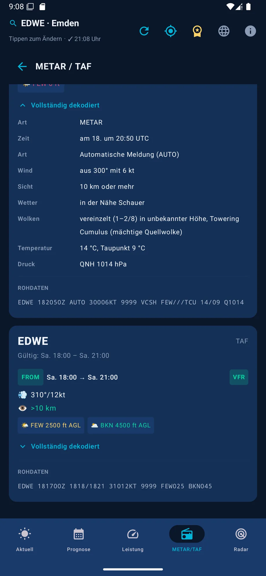
In the VFR Wetter app, you don't need to look these codes up yourself – the METAR/TAF decoder translates them into plain language automatically.